Travellers have been marvelling at Uganda’s Rwenzori Mountains for almost two thousand years. As early as AD 150 geographer Claudius Ptolemy—based on testimonials from traders who had ventured inland from the coast—created maps indicating the location of snow-capped mountains in what is now western Uganda.
Traders reported that locals referred to these mountains (now known as the Rwenzori Mountains) as the ‘Mountains of the Moon’ for their snow-capped peaks. For nearly two millennia explorers and geographers largely believed these Mountains of the Moon to be the source of the Nile, but failed to confirm their location. It wasn’t until 1889 that the famed explorer Henry Morton Stanley was finally able to identify the mountains marked on Ptolemy’s maps.
Though it was ultimately discovered that the Rwenzori contribute only a fraction of the volume of water to the Nile, the Mountains of the Moon have remained a key attraction for adventurers. In 1906 the Duke of Abruzzi was the first known trekker to summit Margarita Peak—Africa’s third tallest, behind Kilimanjaro and Mt. Kenya. Since then the mountain has become a destination for hikers eager to explore the range’s unique flora and fauna and more adventurous trekkers seeking physical challenge and unparalleled views.
Located at Uganda’s western border with the Democratic Republic of Congo, the terrain of the Rwenzori ranges from rainforest to bamboo forest to bog to glacier, hosting everything from giant lobelias and the Rwenzori turaco to heather trees that drip with moss and black and white colobus monkeys.
Visitors can arrange treks through the Rwenzori, anywhere from five to ten days, and can attempt any of the range’s six main peaks: Margarita (5109m), Alexandra (5083m), Speke (4890m), Emin (4791m), Gessi (4715m) and Luigi di Savoia (4627m). Sample itineraries are provided below.
Rwenzori mountain trekking itineraies
Main central circuit with Margarita Peak (10 days, 9 nights)
Day 1: Arrive at Entebbe international airport
Upon your arrival at the airport, you will be met by one of our drivers or guides who will welcome you to Uganda and give you highlights of your trip itinerary. Transfer to hotel in Kampala city or Entebbe town depending on the time of arrival.
Day 2: Kampala – Kasese town
After an early morning breakfast in Kampala, you will drive to Kasese via Fort Portal. The Kyonjojo plains will provide you views of rolling tea plantations before you arrive in Fort Portal town, where you will stop for lunch. From Fort Portal proceed to Kasese town under the shadow of the Renzori Mountains. Overnight in Kasese town (Sandton Hotel) or directly to the base camp town of Ibanda near the base of Nyakalengija.
Day 3: Kasese town – Nyakalengija – Nyabitaba camp (4-5 hrs)
After breakfast transfer to Nyakalengija, the start off point where you will meet your mountain guides and escorts. The walk begins through community homesteads and plots of land featuring coffee plants and banana trees and brings you to the gate of the Rwenzori Mountain National Park for registration. Once registered, you will set off and from the get-go you will be able to spot three horned, two horned and one horned chameleons, as well as various butterflies. If you are lucky you may even see a mountain elephant. After crossing the Mahoma River you will take your first break, re-energizing with a packed lunch before starting the steep ascent to Nyabitaba camp, located on a ridge at 2659m. Dinner and an overnight at Nyabitaba hut.
Day 4: Nyabitaba – John Maate camp (6-7 hrs)
An early rise at Nyabitaba will most likely treat you to a panoramic view of the Portal Peaks, providing you ample motivation for your second day’s trek to John Maate camp. After setting off just a few meters from the camp you arrive at the central circuit junction, choosing the descent through the Mubuku River valley to Kurt Shefer bridge—a beautiful attraction where the Mubuku and Bujuku rivers converge, forming the main stream of the Mubuku River which drains its waters into lake George. From there you follow the Bujuku River valley leaving the mountain forest zone behind and proceeding through the bamboo zone and the heather zone, where trees with white hanging moss referred to locally as “old man’s beards.” Parts of the trail involve beautifully constructed but difficult-to-navigate wooden ladders and foot bridges. Proceed carefully. Eventually you will pass the old huts at Nyamuleju and begin to spot the famous giant lobelia plants. Soon after you will reach John Maate hut, tucked into a mountainside at 3550m.
Day 5: John Maate camp – Bujuku camp (5-6 hrs)
This day’s hike takes you through stunning valleys with giant lobelias, groundsels, heather trees and everlasting flowers. Part of the valley is traversed on a wooden boardwalk. From there it is a steep walk through the Upper Bigo Bog—gum boots required. Ascend to Lake Bujuku, a glacial lake filled with snow melt from Mt. Speke, Mt Stanley and Mt Baker, on the edge of which is Bujuku camp at 4640m.
Day 6: Bujuku camp – Elena camp (2-3 hrs)
It’s by this day that hikers make a choice. Some may opt for the Escort – Eliot pass to Kitandara Lakes, where an alternative camp is situated between two lakes. The route to the camp passes between rock boulders with views of Mount Baker and Mount Albert. For those seeking a greater challenge and a chance to summit Africa’s third tallest peak, the hike to Elena Hut is 2.5km over slippery rocks. Hikers will find themselves happy to rest in a hut at 4640m just under the peak of Mount Stanley.
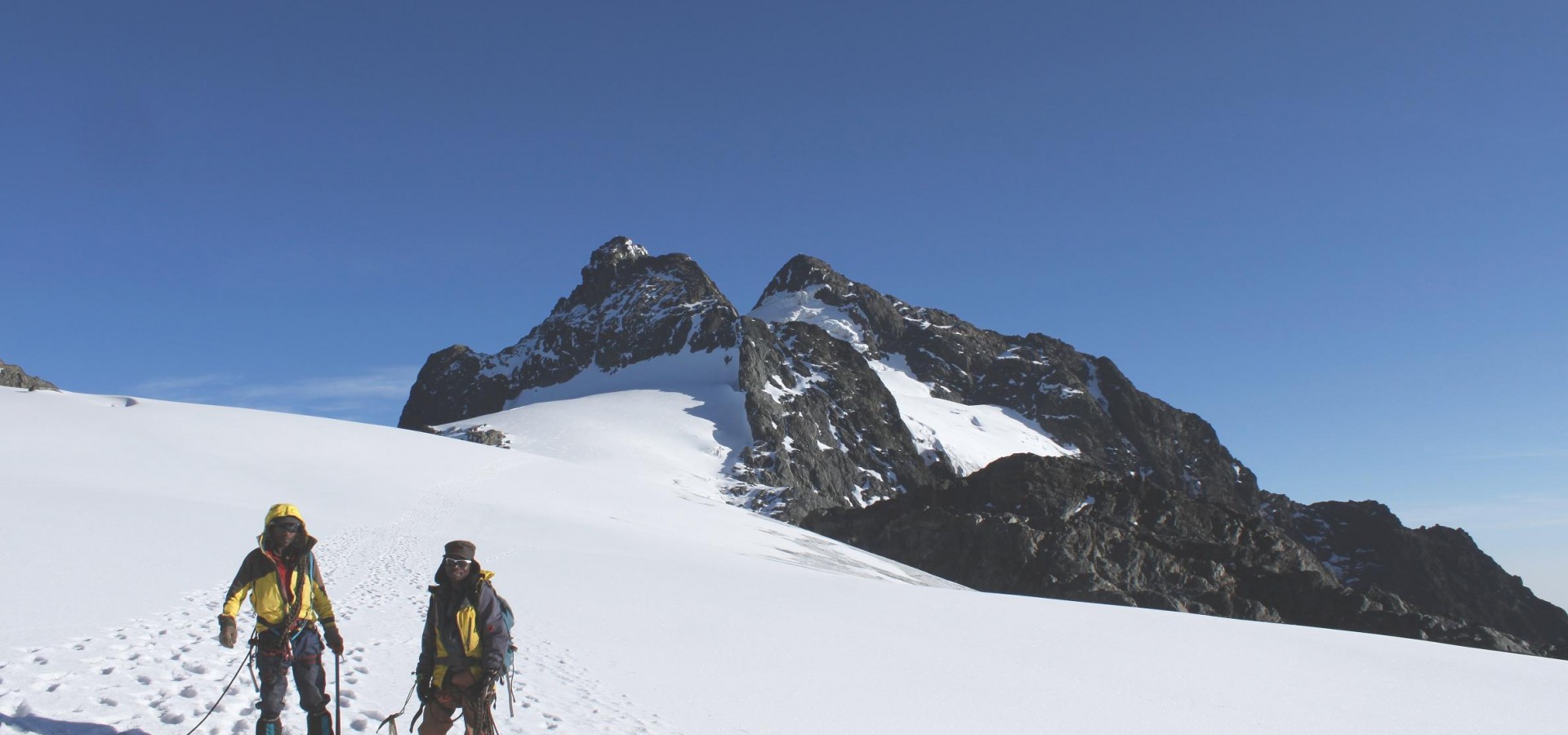
Day 7: Climbing Margarita Peak (5-6 hrs ascent)
You will wake up early around 5:00am for breakfast. On a clear day with good weather, you are able to view Mt Speke, Mt Baker and Mt Albert. After an initial rock scramble you will reach the snow line, where you will don crampons and ropes to prepare for the traverse and ascent of the glacier. Once you have completed the challenging ascent of the glacier you’ll have a last stretch of rock scramble before reaching Africa’s third tallest point, Margharita Peak (5109m). On the summit you can enjoy snacks, a warm cup of tea and views of Uganda and the Democratic Republic of Congo. Descend to Elena camp for lunch and to Kitandara Camp at 4027 for an overnight rest after a long trip. The descent will take you 5 – 7hrs, depending on conditions and fatigue.
Day 8: Kitandara camp – Guy Yeoman camp (5-7 hrs)
On this day, clients who have opted to climb Mt Baker will wake up to hike the 2 kms to the peak. All hikers will eventually leave the Kitandara Lake valley and then descend through boggy areas with familiar but beautiful vegetation such as giant lobelias, everlasting flowers and heather trees with hanging moss hanging. You will find yourself in a valley tracing a stream to Guy Yeoman camp.
Day 9: Guy Yeoman camp – Nyabitaba camp or to Nyakalengija start point
Descend from Guy Yeoman through the heather zone and some bog to the Kamato and Kichuchu rock shelters. Enter the bamboo zone and pass to the Kichuchu Bridge, after which you re-enter bamboo forest before reaching Nyabitaba hut, the site of your first night’s stay. Depending on how you feel you may continue the descent to the trek’s starting point in Nyakalengija, where you may stay in Hotel Sandton or Ibanda base camp. Others may choose to split the final descent into two days, staying one final night in Nyabitaba hut.
Day 10: Kasese– Kampala
After a good night’s rest and a hot shower you will proceed to Kampala again via Fort Portal. Transfer to Entebbe International Airport is provided.